Showing posts with label map. Show all posts

Wednesday, March 21, 2012

Real-Time Internet Visualizations

Have you ever been frustrated by your internet speed, or worried about attack traffic on the internet? Well, thanks to Akamai, owners of a cloud platform that all of us have likely used at one point or another unknowingly, you can see real-time maps of network attacks, internet latency, and network traffic.

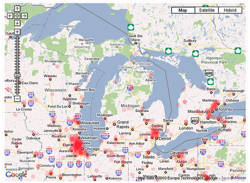
Here's what the attack map looked like just moments ago, with a zoom-in on the continental United States:


As you can see, the overall number of attacks is about 15% higher than usual. California has suffered the most attacks in the past 24 hours, with 32. Not surprising, due to its high population.

To make this map, Akamai collects data on the number of connections that are attempted, the source IP address, the destination IP address, and the source and destination ports. The packets captured, they say, are generally from automated scanning trojans and worms looking to infect new computers scanning randomly generated IP addresses.

These maps are updated in real time, so check them out here however frequently you'd like.

Wednesday, September 22, 2010

Race and ethnicity: Detroit

Eric Fisher has created race and ethnicity maps based on census data of many major cities around the United States, with the end result being almost artistic.

By clicking on the image you are able to see tagged locations, and even some explanations of the divide in Detroit.

Detroit not your nearest hub? No problem! Click here to view other cities.

Thursday, September 02, 2010

Did you know? Not all maps are of earth.

In 1829 this detailed map made by ML Frankheim was published in Popular Astronomy

Karte des Vollmondes nach Mayer, Schroter und Guithuisen - Popular Astronomy by ML Frankheim, 1829, Braunschweig (SLUB) via Peacay

The mapping of objects other than the earth started well before we were able to actually take photographs of surfaces.

Thursday, August 19, 2010

A night on the town in Harlem, In the 1930's of course.

While Harlem may not be thought of as the place to go for a bit of night entertainment for all, but in the 1930's it was the a hopping and significant center for Jazz clubs. Click the Image for a closer look.
A Nightclub Map of Harlem
via Mike_Thibault

Monday, August 02, 2010

Got Spam?


Like a majority of the population when spam appears in our inbox we delete it or send it to the spam folder with no regard for what message it holds, perhaps getting a chuckle out of he subject.
But have you ever wondered where it originated from? Thanks to the all knowing power of google you can peruse a map of malicious ip addresses and see that maybe... just maybe it could be someone next door in your little town filling your inbox with advertisements for special enhancers.
malicious ip address map- Michigan
Check it out for yourself here.

Thursday, July 29, 2010

What would the earth look like if it stood still?

Well with the help of ArcGIS (which we have for use at the map library) we can see.

Through predicting how the changes in gravity would change the water masses and where they would settle.
Michigan would not only be great lake-less we would also be a part of the newly formed oceans!

To read up more, the full article here.

Thursday, July 22, 2010

How happy is the nation?

A recent study by researchers from Northeastern University and Harvard University of twitter data has given us an interesting look into the nations moods. With a simple idea in mind we are able to see how moods fluctuate of those who tweet over a 24 hour period. Words are given a rating, Happy or sad and with the resulting data the scientists were able to see how moods naturally fluctuated in zones through out the day and through out the week. Sundays are a high point for most, with Thursday being the down point in the week pointing to the 5 day work week of many.